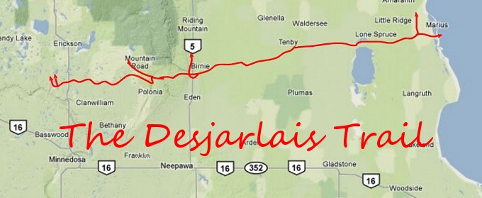
The Desjarlais Trail of Manitoba, Canada
The rediscovery of the trail was no small feat as it weaves
through and around all the ancient obstacles of the time. Many of these
obstacles have disappeared due to road and agricultural needs, so
walking the fields was needed. The trail was known as the Desjarlais
Trial, but it also went by the names; The Turkey Trail and The Glass
Tail (because of all the broken European china and glass that can be
found along its route). The trail’s direction was east to west and just
south of Riding Mountain, from Lake Manitoba to the Rolling River
Reserve south of Erickson. There is no way of knowing how old this trail
dates but its popularity grew after Indian Reserve Treaty No 2 was
signed on August 21, 1871. This was about the same time as European
settlers using Red River carts settled the area. The trail provided a
marked route to follow and a way around ponds, lakes, ravines, and
hills.
Below are topographic maps of this trail.
Unfortunately they are originals from that summer and are some what
worn.
I believe this important historical trail is something that
should be recorded in the histories of these municipalities: Harrison,
Minto, Clanwilliam, Rosedale, Lansdown, Glenella, Westbourne, Lakeview,
Alonsa, Amaranth, and the Rolling River Reserve.
Desjarlais Trail –
Rolling River Reserve
to Mountain Road
Desjarlais Trail –
Mountain Road to Elk Ranch

Desjarlais Trail -
Elk Ranch to Bernie
Desjarlais Trail -
Bernie to Tenby
Desjarlais Trail –
Tenby to Waldersee

Desjarlais Trail –
Waldersee to Big Grass Marsh

Desjarlais Trail –
Big Grass Marsh to Sandy Bay Reserve
View Larger Map
Bill Dayholos
essence2@telus.net
June 21 2011
HOME