Home Schematic of Sites The Time Shaman Stone Circles Modern Mythology

The Whiteshell Petroforms
The Manitoba Whiteshell Petroforms are a mystery to the public and academics alike. The creators of these ancient rock formations did not leave many clues to what they were used for because they were never intended to be part of a public’s understanding. This has always been the profile of the secret shamanic world and goes back tens of thousands of years.

Tie Creek, the largest site in the Manitoba Whiteshell area - Feature # 1
Don’t think for a second that the Whiteshell Petroforms are just ancient sites. They are not camp sites, kill sites, or burial sites, they are spiritual sites. For the general public the word spiritual draws an immediate association to religion. Shamanism is not a religion it is a method of connecting personally to spiritual levels (the nonphysical). Although shamans can get together to share experiences it is still an individual experience and understanding. In a shamanic journey the experiences into nonlocal realities can reach to the highest levels human consciousness is capable of. Petroforms and pictographs are experiential creations from contact with these nonphysical realities. Interpreting them without these experiences will always be a misinterpretation. (For some examples of this see the link at the bottom of the page called “Interpretive Misconceptions of Deciphering Petroglyphs”.) As you read on and view the photos of these Petroforms remember these sites were for shamanic purposes only.

Tie Creek Feature # 3 - see diagram below

Tie Creek Feature # 3 - see diagram below
In this page and related pages I have provided some diagrams and photos of different sites and their elements but unfortunately the sites are very unphotogenic. The moss and lichen growth covers the base granite and the rock formations on it with the same living pattern. This makes them almost camouflaged; as there are times one has to be almost standing beside a Petroform to see it.

Manitobans are extremely fortunate to have these rock formations in their backyard for if this area (the Whiteshell) were fertile soil they would have been lost a hundred years ago. The Whiteshell shamanic sites are time capsules preserved for present day recognition and as a source of learning. Bannock Point is the only recognized public site, unfortunately it is a disturbed site, with some of the Petroforms being replicas (as per “Papers in Manitoba Archeology” No. 14 Studies in Manitoba Rock Art, Petroforms 1986). The only value these features have is to distract the general public from looking for the undisturbed sites (see below for some examples of completely lost sites). I know there are many people that would like to see one of the undisturbed sties. For people that are aware of their energetic surroundings Bannock Point only has a few good elements. To really experience the true quality of these ancient energy sites one needs to be with an undisturbed site.

Tie Creek Feature # 4 - see diagram below
Without opening the “flood gates” providing photos of some different sites is my attempt to help people who want to truly make connect to this past shamanic energy. One will still have to do the backwoods searching as I did years ago. Upon finding a site I trust people will respect the site and treat it with more reserve than they would with a modern church or place of worship. These sites are far more vulnerable than modern places of worship because the original ancient energy cannot be replaced or replenished. They need protection from more than physical abuse as any ceremony performed at a site changes its original energetic profile forever. All the sites have layers of energy that is latent in the site. With shamanic training one can access these different layers and the individuals that injected their energy into the site. Performing a ceremony at a site pollutes this energy as it adds a profile that is completely foreign, regardless of one’s perceptions.

Tie Creek Feature # 4 - see diagram below
If one feels an association with these sites and brings to them modern understandings or modern shamanism it would be advisable to create a new site adjacent to the old one, rather than change the original sites energy. These sites were chosen thousands of years ago in secrecy. They were never intended to be visited by anyone outside of the shamanic orders. In the past these shamans went out of their way to create sites that were far enough away that they would not disturbed by their own people. The general public has no idea how important this is to a shaman (past or present). Their space and place of connection must remain undisturbed on all levels as it is useless to them if it is disturbed. These places are connection point to some of the deepest spiritual experience a human can ever achieve. They connect to regions of non-physicality that transcends any conscious level of understanding.

Tie Creek Feature # 2 - see diagram below
Many of the sites are located a few hundred yards off the main highway between Bannock Point and White Lake. Avoid the month of July for searching as it is typically a bug invested world there. The end of September and on is the best time to look.
Tie Creek Feature # 3
To connect to a site come in silence and stay silent. You will never hear this level of teaching if you are talking. Sit, stand, or lie down and meditate in silence, with the exception of toning or drum to use as a bridge for connection. You will connect to the energy, whether you feel it or not. The energy will be working with you as you might not be aware of it for weeks to come. The more time you spend there the more it will make contact with your consciousness. For more information of this see: Connecting to Sites and Artifacts
What is a Shaman link: Page 9 of "The Time Shaman"

Tie Creek "The Wave" - see diagram below
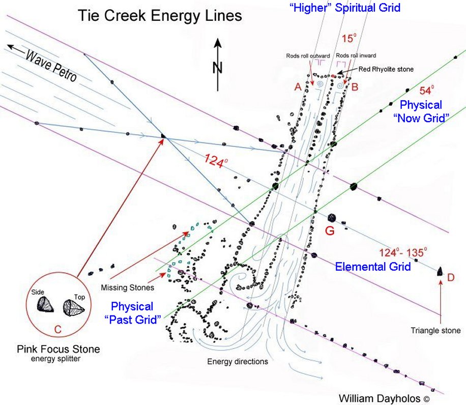
Tie Creek Energy lines, found by Dowsing - click for larger image.
The proof that the ancient shamans were after the Grid Energy and not aligning to factitious star systems.
For more information see Dowsing

Tie Creek energy lines, with prism stone in center - click for larger photo.

Energy Prism used to balance two energy lines - click for lager photo.

Tie Creek feature #1

Tie Creek, Feature # 1

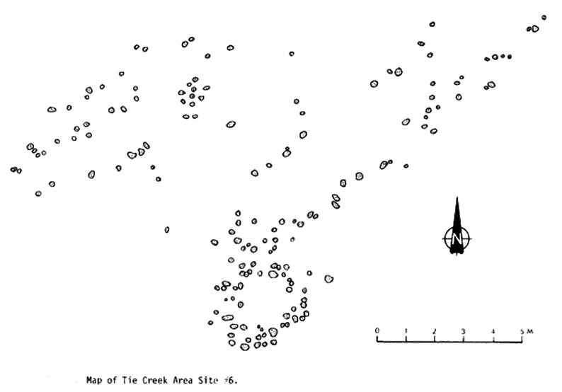
Tie Creek, Complete Site
(Chronology, as taught by shamanic work at site.

Tie Creek, Feature # 1
Energy Angles
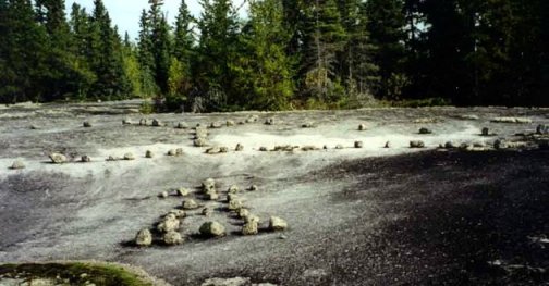
Tie Creek, Site # 6

Tie Creek, Feature # 3

Tie Creek, Feature # 4
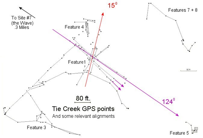
Tie Creek GPS Waypoints

Tie Creek "The Wave"

Tie Creek Feature # 2

Tie Creek Feature # 2

Tie Creek Feature # 5

Tie Creek Feature # 8

Tie Creek Feature # 7

Tie Creek Site # 1 "The Heart"
Other Petroform Sites

Bannock Point Site (one of the largest features)

Bannock point Woman (the male petroform was stolen years ago).

Basket Falls Petroform Feature # 1 (facing south) - see diagram below

Malloy Lake Site Petroform - see diagram below

Malloy Lake Site Petroform - see diagram below

Rainbow Falls Petroform Feature # 4- see diagram below

Basket Falls Petroform Feature # 1 (facing north)

Red Rock Petroform

Basket Falls/Rainbow Falls Petroform (I call it the Hill Top Site)
It appears that one of my favorite sites has recently been destroyed (the Hill Top Site shown above). Not living in Manitoba anymore I cannot confirm this but using Google Maps it does not look good. See photo below of what appears to be a tree logging pillaging. Why this site was so interesting is because the one that created it (eons ago) was an accepting shaman. This was a great site for teaching others as he was a powerful male shaman in his 30s with an open level to allowing new contacts. Most ancient shamans are not so open to strange modern levels of consciousness. Modern human consciousness, regardless of ethnicity, is very foreign to the ancient shamanic levels of consciousness.

Hill Top Site of Basket Falls – looks like it has been recently destroyed.

The above map shows the route of an ancient canoe portage between Rainbow Falls and Basket Falls. It is still marked by ancient cairns along its route. Look for rocks piled up, these are the ancient cairns. It is a safe area to explore because (with a compass) going in any straight direction will led you to a swamp, river, or the highway.

Turtle Petroform at North end of canoe portage.

Basket Falls Site, at waters edge.

Looking south from Basket Falls, waters edge site

Bannock Point, feature A
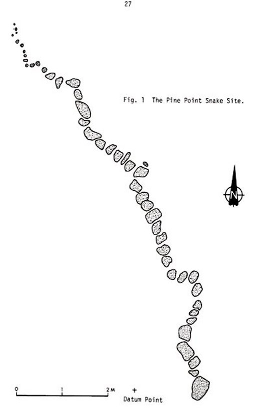
Pine Point Petroform

Astwood Site, George Lake

Jessica Lake Petroforms
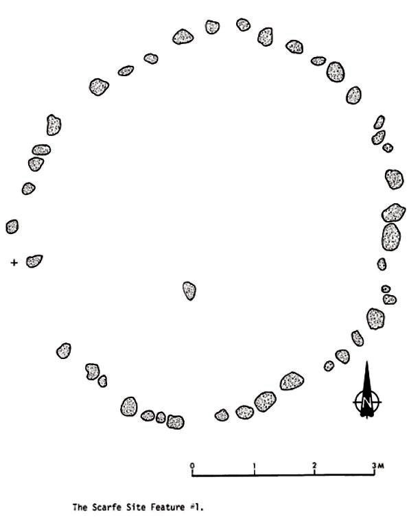
Scarfe Site Petroform, Feature #1

Malloy Lake Site Petroform

Basket Falls Petroform Feature # 1

Rainbow Falls Petroform feature # 4

Basket Falls Feature # 2

Red Rock Lake Site
Destroyed Sites


Other Manitoba Sites

Alonsa/Glenella Site
(Dowsing Energy found there)

Alonsa/Glenella Site

Alonsa/Glenella Site
Lines found by Dowsing

Alonsa Site - another unphotogenic site
The Dand Site
Possibly a lost site near Dand, Manitoba. I have never tied to find it.


Click on map for larger image

Turtle Mountain area Petroform
This a very exciting website find. I would love to know more about this Petroform, especially its correlation to true north or magnetic north. Notice the shape, it is the same as 2 Tie Creek Petroforms. It appears to be a defendant match to the same shamanic level of understanding.
http://intangibleoralhistory.wordpress.com/2011/06/

Souris River Petroform - another unknown
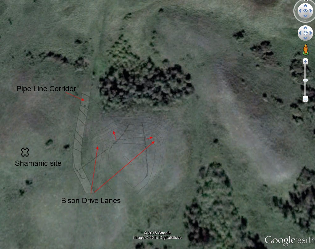
Associated Shamanic Site at Toews Bison Drive Complex
(Located in Manitoba near the Saskatchewan border)
The site (DkMg-4) consists of eight discrete features. These features includes include tipi rings, cairns, a bison drive complex and a shamanic site maybe even two. The features are in two clusters; the occupation area (about 50,000 m2 in the valley beside Pipestone Creek and the other features scattered along the south rim of the valley over an area of 30,000 m2.

(Click to enlarge)
(Click to enlarge)


East drive lane looking south & West drive lane at crest of hill, looking north.

Tipi Ring

Feature #2 - the shamanic site on the west knoll, overlooking the drive lanes. This feature is an open rectangle facing east with a small semi-circular projection on the southwest corner.

The Turtle's Brow, Turtle Mountain Manitoba
I know nothing about this site including location. Maybe someone out there does.

One of the first things archaeologists noticed about the Whiteshell Petroform sites are they line up in straight lines across the map, regardless of terrain, lakes, and streams. There is a reason for this and it comes from the nonphysical again.
For further reading see: Shrines, Caches, and Medicine Bags
Also see: Researching Ancient Sacred Sites

Click on images for larger view.

For more on the grid see Modern Mythology
Working at Ancient Sites
An excerpt from The Time Shaman Pages. For full understanding of Grid Lines please start at the beginning.
(The beginning of the teaching)
The ancient structures were built as collectors of energy that allowed shamans to enhance their abilities and experiences. This was accomplished through knowledge of the universal structure in conjunction with the geographic locations. These structure or “machines” made it easier to attract and store the avenues of choice. Creation in the physical is a combination of energies. At these sites one can focus specifically at one part (angle) or use multiple points of focus. There are no rules per se but one must understand the general purpose of the angles. As shown in prior chapters there is a time orientated structure at all sites built on vortex areas. Facing the direction of choice is important and with this the correlating desire for experience. Efficiency (quickness in time) is a result of desire aligned with spiritual connection and physical positioning. Generally circle sites are more oriented to higher vibratory states while square and triangular are more physical creators. Pyramids are machines that focused in three dimensional alignments with the same angle. This could include journeys (contacting to physicals outside this reality), power of creation in the physical, physical based knowledge, and so on.
Remember this reality’s present position and to a future focus is angled at approximately 51- 55 degrees. This is why many ancient sites are aligned to these 50ish angles. Using a 3 dimensional sphere as one’s compass, see the angles that apply. The opposite angles of 234 degrees (of 52) shows the way to our past. Both angles represent the physical connective angle but the 234ish angles are the past physical and one’s foundation in their physical. Family ancestors are along this back angle. Focusing to the elemental or animal guardians would be found in the range of 120 - 135 degrees. Going deeper into the lower vibrational levels would take you to the Dorajuadoik level of 160 + or -. Tilting any angle sideways or up and down (3D) will result in variations of this energy so one must experiment or rely on intuition to fine tune this.
This is the biggest problem with ancient sites. Their angular structure is typically set up with alignments of past earth processional tilts. Unless a complete time cycle has taken place the structure is typically out of sync with our present. Higher vibratory site structure should be aligned to 0 degrees and this is why some sites are presently at 12 – 15 degrees off north (processional shift). In this modern time period the benefit of working at ancients sites is not in the site itself (unless researching past shamanic understandings) but in the general area. Typically the main vortex area has moved over to the side and out of the archeological site itself. With this understanding one can comfortably create their own site without disturbing any archaeology or energy of the site. Dowsing rods or pendulum can help in finding this new vortex position.
Dating the site can be calculated by this deviation, assuming it has not cycled around a couple of times. If a site goes back too far there is another angular problem that is present but its subject is too big for this book. Here is a link to its direction if you curious. http://www.nealadams.com/index.php/science
The best thing I can say is to experiment and experience it yourself. This is because everyone will have different results depending on their awareness level, and desires. Also remember that because of the differences between the sites and one’s own process there could be immediate results or it may take weeks to see any changes. This is one of the most important things to understand. Like all evolution of spirit one must be ready for change. If one is not ready to change do not expect instant results. This sounds easy but we hide our fears of change, and so well that most are not even aware we have any.
Don’t forget that this is also based on a 3D sphere, with one in the center of it. The angle’s in this sphere can be seen as “rings” or hoops of energy around the sphere. In my teachings they never referred to the opposite degrees of an angle as its numerical extension. So 53 is 53 degrees all the way around the sphere. 45s and 90s are the same with the only difference is the axis position of 0 and 180 degrees (see diagram below). There is so much around this subject and it gets very complicated but the purpose of this text is to introduce people to this lost understanding.
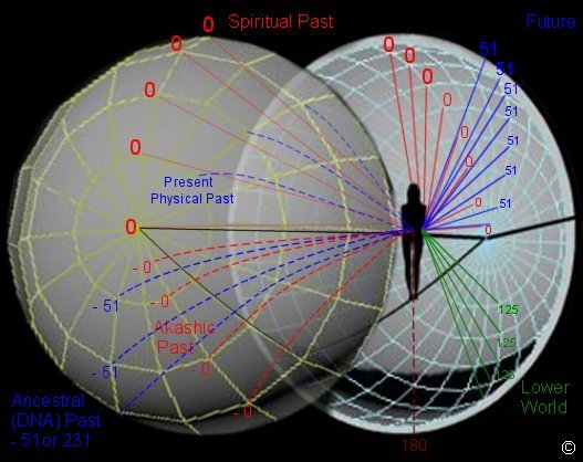
Standing in a vortex or an ancient site (assuming the site’s energy has
not shifted) true north would be “0” degrees at the horizon, in front of
you. Arching up in at the same latitude of 0 to one’s crown is the
highest vibrational level. Arching backward behind one’s body, on this
same latitude, is going back into the present physical body’s
spiritual past. The further back the angle the deeper back in time
one goes. Continuing on the same arch back behind oneself and now below
the horizon is our spiritual past, but in Akashic (DNA) levels.
Repeating this exercise in another angle produces connections to other
aspects of us. For instance starting at a “physical present” (51 – 55)
just below the 45 degree angle represents now. Grounding this “now” into
our future would be arching down towards the horizon. (The purpose for
these 50ish degrees in pyramids.) Swinging up on this same longitude
angle to our crown is the highest vibrational (spiritual) level for our
present physical existence. Swinging backwards past our crown
takes us back in time of this present lifetime. Continuing the sweep
backwards and below the horizon (on this 50ish angle) is a connection
to our ancestors (if one is into ancestor worship). It is actually
our past DNA design, our past lifetimes in this body configuration.
Each angle and its sweep around the arch have their own specific energy
connections. No connective angle can exist without all the other 360’s
contribution (balance). On larger cycles, into the larger spheres,
connections with other reality types that shared our 8 pack are
presented. The 8 different 45 degrees are as they have been described
above. The horizon or 90 degree angles are the physical creator
types or Jinn connections (a huge topic that involves different angles
in different shell levels). One last comment; this can be done at home
in front or behind one’s shrine.
The Time Factor at Ancient Sites
Time has to be addressed as it is one of the main components of the “power”
that sacred sites have. It is the time factor above all that produces
the most dramatic results. Other than the obvious measurement of events,
from a shaman’s view, time can be observed as structure. The biggest
problem describing the time aspect is the number of views or properties
that can be focused on. Time has a distinctive pattern and a schematic.
How we see this pattern depends on what level or angle of the structure
we are looking at. At one point we see a grid, another ratcheting
spheres or cubes, and at another level moving structures that spiral. It
can also be sequential patch works or pockets of time displacement
interacting with one another. It is all the same structure and it is all
the same movement, just different aspects of the whole creation. The
duration of time can also vary from one dimensional level to another
including the physical.
Another Site of interest:
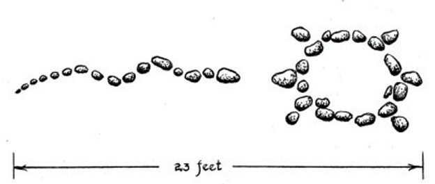
What I found interesting the other day was an article about a 9000 year old Caribou corral formation found on the bottom of Lake Huron. Three things stand out are; was it a caribou corral, as it has a lot of similarities to Tie Creek, two where are the broken projectile points always found at kill sites? Maybe in the future they will show up confirming a kill site. The last thing is the design of a Caribou drive, notice the desired funnel in the diagram below, as described by an Nunamiut hunter.


Click on image for larger one


A Must Read!
They’re Alive! Megalithic Sites Are More than Just Stone - See more:
More on the World Grid
The Tie Creek Site
Modern Mythology - New
The Schematic of Time and Ancient Sacred Sites
Stone Circles - NEW
Interpretive Misconceptions of Deciphering Petroglyphs
Free Shamanic Music and eBook Downloads from Talking Drum
Opening photo:
Description by Edward S. Curtis: The subject of this plate is a female shaman of the Clayoquot tribe. The ceremonial washing of shamans is much like that of whalers and other hunters, consisting mainly of sitting or standing in water and rubbing the body with hemlock sprigs in order to remove all earthly taint, which would offend the supernatural powers. 1915 - 1916.
Diagrams from “Papers in Manitoba Archaeology” No. 14 Studies in Manitoba Rock Art, Petroforms 1986.
View Larger Map
May 19, 2014 ©
Updated June 1, 2014
Bill Dayholos